About the Loddon Mallee region - Central Victoria
The Loddon Mallee region - Central Victoria is characterised by a large rainfall gradient from the wet and hilly Macedon Ranges covered in tall thick forests in the south, to Kerang in the north which has less than half the annual rainfall and is surrounded by croplands. The southerly areas are also where most people live and many commute to Melbourne for work.
How Victoria manages bushfire risk
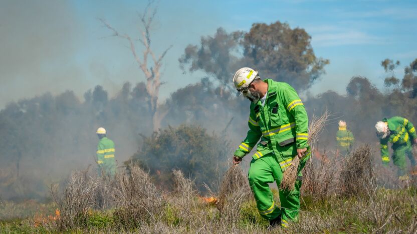
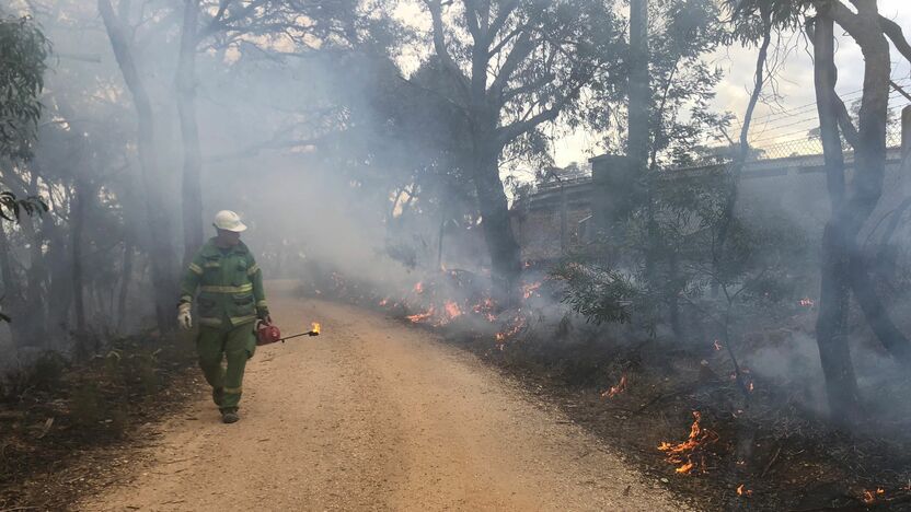
In Victoria, we conduct fuel management activities like planned burning, mulching and slashing to reduce the risk of bushfires causing harm to things we care about. We also conduct planned burning to support plants and animals that need fire for their survival.
On this page
Identifying what we care about
Ultimately, we manage bushfire risk to protect the things we care about.
Our bushfire management planning across the state seeks to protect human life, private property, our economy, critical infrastructure, cultural heritage and the environment.
Here in the Loddon Mallee region - Central Victoria, we have worked with local communities and consulted scientific data and experts to understand where the most important values and assets are in our region and how to protect them from bushfire.
Here's some examples of the different values and assets we considered in our fuel management planning.
Human life
Major townships at risk from bushfires in Central Victoria include Bendigo, Castlemaine, Wedderburn, Inglewood and communities surrounding these towns, plus villages in the Macedon Ranges.
During summer, the Red Gum forests along the Murray River attract thousands of visitors, especially during school holidays and for events like the Southern 80 water-skiing race.
Understanding where residents live and visitors spend time in Central Victoria is key to protecting lives from bushfire.
Natural environment
Protecting our natural environment is important to communities in Central Victoria. Public land provides important habitat for many species, and ensures it is cared for for generations to come. Habitat also exists on private land.
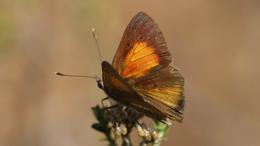
Central Victoria is home to a range of threatened species, including the Eltham Copper Butterfly, Spiny Rice-flower, Pink-tailed Worm-lizard, Powerful and Barking Owls and rare native orchids. Many of these plants and animals live in small patches of forest near townships. We work to balance the need to protect these plants and animals with the need to protect life and property from bushfire.
Habitat for the Pink-tailed Worm-lizard is only found in a very small area. Key populations are in parks within the sprawling township of Bendigo. This requires land managers to strike a fine balance between works to reduce bushfire risk to the community and the needs of this endangered lizard.

Pink-tailed Worm Lizard (Aprasia parapulchella) - Peter Robertson
By contrast, habitat for Barking Owls is widespread across Central Victoria (and beyond). Despite this, these threatened birds are uncommon in this area. This is because areas of habitat in Central Victoria are often small and fragmented. Barking Owls are very territorial and need large, exclusive areas of high-quality habitat to survive.
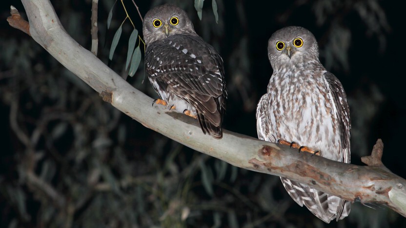
Barking Owl (Ninox connivens) - Chris Tzaros
Priority areas for these and other animals sensitive to fire and of conservation or social concern are used to shape our fire management strategies to ensure adequate habitat is present on public land.
These areas are ranked in importance from Highest to Moderate depending on the number of priority animals dependent on that area.
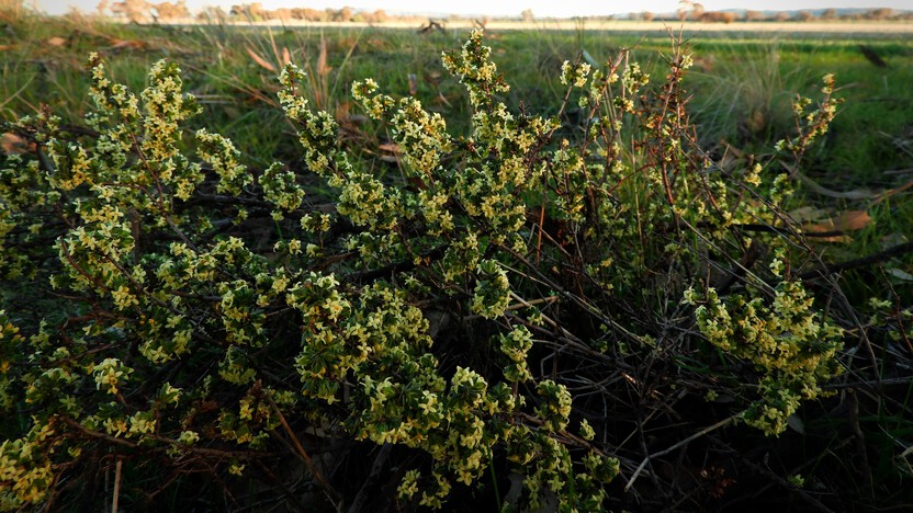
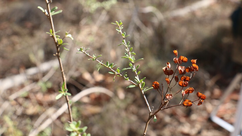
Spiny Rice-flower (Pimelea spinescens spinescens): populations of this nationally endangered plant are considered environmental assets as part of the Bushfire Management Strategy in Loddon Mallee Region - Deborah Reynolds
Regional economy
Central Victoria has a growing economy in tourism and agriculture. In the north, land use is dominated by mostly cropping and grazing agriculture. As a major food-producing area, our region is also home to a vibrant manufacturing and service sector.
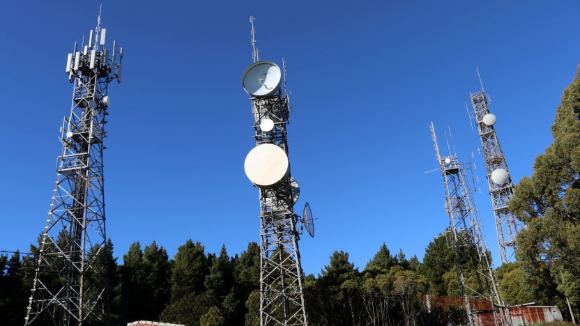
Critical infrastructure
Communications and navigation towers on Mount Macedon and Mount Alexander are nationally important for managing Melbourne's airport traffic and for the Australian Defence Force.
Critical transport infrastructure also includes Bendigo Airport, and road and rail links through Central Victoria.
These transport links play a key role for health services and the agricultural industries, including for grain producers and major livestock processing plants.
As part of our bushfire management planning, we also considered reservoirs and lakes plus water delivery infrastructure, such as Coliban Water treatment plants and pumping stations.
 Traditional Owner Groups
Traditional Owners groups, including the Barapa Barapa, Dja Dja Wurrung and Yorta Yorta peoples, work actively on Country in Central Victoria in partnership with community and agencies.
This work includes protecting cultural heritage and returning cultural burning to Country.
Cultural burning is a practice authorised and led by Traditional Owners.
Traditional Owners conduct cultural burning for a range of objectives, including ceremony, protection of cultural and natural assets, fuel reduction, regeneration and management of food, fibre and medicines, vegetation regeneration, animal habitat protection and healing Country’s spirit.
Our bushfire history
This section contains information regarding past bushfires which some readers may find upsetting. Click to skip ahead to bushfire risk in our region or our fuel management strategy.
Nearly 14% of recorded bushfires in Victoria have occurred within Central Victoria.
Ravenswood was severely impacted in 1969, Maryborough-Avoca in 1985 and Macedon Ranges in 1983 on ‘Ash Wednesday’.
Central Victoria often experiences large fires during extended drought periods. Half of the recorded bushfires in the area have been caused by people (e.g. unattended campfires).
Hot, dry summers that result in very dry fuels mean it doesn't have to be a high fire danger day for Central Victoria to experience destructive bushfires. Destructive fast-running grassfires can occur on days with light winds and temperatures as low as 20°C.
Black Saturday
In the past 20 years, the worst bushfire of Central Victoria was Black Saturday in 2009.
These fires significantly impacted Bendigo and Redesdale, where one life was lost, 41 people were injured and 72 homes were lost. The bushfire also threatened the St John of God Hospital near the heart of Bendigo.
2019-2020 bushfire season
During the 2019-2020, summer bushfires came close to homes and impacted farmland and parks in Central Victoria.
Houses near Huntly were threatened when a 111-hectare bushfire ran through creek line vegetation, making fire truck access difficult.
This bushfire occurred on a southerly cool change with strong winds, making it difficult to control.
A fast-running grass fire near Rochester, which ignited under a Code Red Fire Danger Rating day in November 2019, required six houses to be evacuated, damaged the Echuca rail line and burnt 414 hectares of pasture, livestock and cropland.
Bushfire risk in our region
This map shows the risk of house loss in Central Victoria, which is part the Loddon Mallee region. The map compares where houses could be destroyed by bushfire across the whole region.
Different shades represent different levels of risk. As the shade progresses from yellow through red to purple, more and more houses are potentially destroyed.
The purple areas have the highest risk of house loss. More houses could potentially be destroyed by bushfire in these areas than any other areas in this region.
Computer simulations are used to help us estimate houses lost from bushfires. The simulations measure how damaging bushfires could be in different locations. They assume that the fuels in the landscape have increased to the highest level.
This helps us plan where, how often and how much fuel management we do to reduce risks to communities over years, or even decades.
This map does not reflect any recent bushfires or activities that could change the risk in the region. Importantly, this map shows where there is potential for a bushfire to destroy more houses compared to other parts of the region. It does not show risk to individual houses.
Higher risk areas - Central Victoria forested hills
Castlemaine, Heathcote, Wedderburn and the Macedon Ranges and surrounding villages are some of the areas at highest bushfire risk in Central Victoria. This is because there are large areas of forest on the north and west sides of the communities with houses surrounded by forest. Road access through these areas is also limited, making escape once a bushfire is in the area dangerous.
Lower risk areas - Central Victoria grasslands and croplands
Lower bushfire risk areas in Central Victoria are those surrounded by grassland, like Rochester and Echuca. Although fast running grassfires can be damaging to property, fires in grass fuels are not as hot or intense and so are more easily controlled. The closure of open irrigation channels in the plains mean that fewer firebreaks and less water is available for fires that ignite in these grassy parts of the landscape.
Our fuel management strategy
By understanding what communities care about, where bushfires have happened before and analysing what areas in the Loddon Mallee region are most at risk, we can create a strategy. This strategy tells agencies where, how much and how often to conduct fuel management activities to reduce bushfire risk.
We classify patches of public land as different Fire Management Zones – Asset Protection Zones,
Bushfire Moderation Zones,
Landscape Management Zones
and Planned Burning Exclusion Zones.
In each of these zones we manage fuels differently in terms of the frequency and intensity of fuel management activities like planned burning.
Where we conduct fuel management each year is determined by a range of factors, including fuel loads and weather conditions, such as rainfall.
'Fuel' is any grass, leaf litter, twigs, bark and other live vegetation which can burn. Fuel builds up at different rates in different areas depending on how fast the vegetation grows compared to how fast it decomposes.
The way we conduct fuel management in the different types of Fire Management Zones on public land helps us to reduce the intensity, severity and spread of bushfires across the landscape. This contributes to reducing the risk of bushfires impacting things we care about.
We monitor the success of our fuel management program and publish the results in our yearly Fuel Management Report.
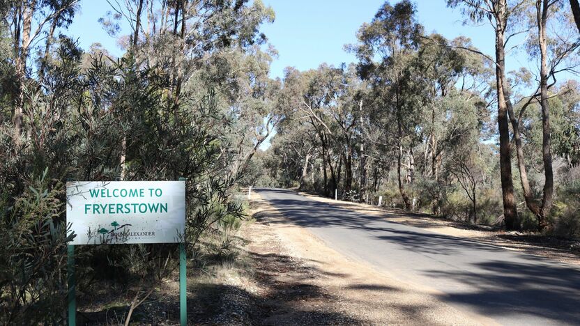
Fryerstown
Fryerstown is a small township in a valley surrounded by forest with limited road access. It is one of the high bushfire risk areas within Central Victorian part of the Loddon Mallee region.
We've placed areas of Asset Protection Zone next to the town to reduce the risk of bushfires impacting the community.
Over time, the Fryerstown community have been connecting with each other, agencies and organisations to increase their understanding of their risks and opportunities to reduce these risks. As a result, the resilience of many of the community members has increased.
Some events have included a presentation from local and international bushfire historian and experts, working together to develop individual bushfire plans and producing online videos.
Some community members have also been working together to identify areas where there could be the opportunity to reduce fuels on common land within the township.
We've also placed Bushfire Moderation Zones in areas surrounding Fryerstown in order to reduce the intensity and spread of bushfire into the community centre.
Kalimna Park, Castlemaine
In Central Victoria, we place Landscape Management Zones in areas where we need to protect important environmental values, like plant and animal species, old growth vegetation and refuges.
Planned burns in Landscape Management Zones will primarily be undertaken to restore ecological values and cultural burning conducted by Traditional Owners.
Kalimna Park, next to Castlemaine, is an example of where bushfire management actions to reduce risk to life and property assets need to be balanced with environmental values (e.g. Eltham Copper Butterfly) and the amenity of this popular park.
Intensive fine-scale risk analysis has enabled us to reshape Asset Protection Zones and Bushfire Moderation Zones to reach a fuel management balance that has less of an impact on environmental values, but still reduces bushfire risk to properties around the park and areas like Moonlight Flat and Chewton.
To further protect the Eltham Copper Butterfly in these areas, we also set aside small areas within Asset Protection and Bushfire Moderation Zones where we don’t undertake fuel management activities.
Bushfire Risk Engagement Areas (BREAs)
To protect the things we care about, agencies and communities need to consider ways of reducing bushfire risk across both public and private land.
On public land, our fuel management activities are undertaken across different Fire Management Zones.
To support bushfire risk reduction on private land, we've identified Bushfire Risk Engagement Areas.
Bushfire Risk Engagement Areas in the Loddon Mallee region - Central Victoria cover both public and private land and help fire agencies to prioritise engagement with the community about managing fuels where it can be most effective. This includes considering a range of actions to reduce bushfire risk.
Where and how we engage with the community will also be informed by current conditions, such as fuel loads and rainfall.
Managing fuels on private and public land begins with a conversation about the benefits and limitations of fuel reduction to meet the needs of our local community and environment.
There is no new legal obligation for landowners within Bushfire Risk Engagement Areas to reduce bushfire fuels on their property.
By working together, land and agencies and communities will be able to better protect the things we value from being impacted by bushfire.
For more information or to get involved in fuel management activities on private land, contact your local CFA District.
Bendigo
In Central Victoria, many properties are nestled in or adjacent to public and private forest blocks. Around Bendigo – known as the ‘City in a Forest’ - many small-scale mechanical fuel management activities are used in conjunction with planned burns to reduce fuels located very close to homes on both public land and private property.
Benefits of this mechanical fuel reduction in densely populated areas is that it’s low risk and does not impact the community with smoke; however, the effects are short-lived and only suitable for small areas. These mechanical works are also being used to improve access by fire trucks to control bushfires.
This concludes our Loddon Mallee region - Central Victoria strategy. You can find out more information by downloading the full Bushfire Management Strategy.
Return to the state view to learn about the strategy for the rest of the Loddon Mallee Region (Mallee), or to see another region's strategy.