About the Loddon Mallee region - Mallee
The relatively sparsely populated semi-arid Mallee area of Loddon Mallee Region is known as the food bowl of Victoria with its fruit and nut orchards irrigated by the Murray River on the northern edge and surrounded by seas of grain crops. In this area, public land in is mostly concentrated in the large blocks of Murray Sunset National Park, Hattah-Kulkyne National Park, Big Desert Wilderness Area, Big Desert State Forest and Wyperfeld National Park.
How Victoria manages bushfire risk
In Victoria, we conduct fuel management activities like planned burning, mulching and slashing to reduce the risk of bushfires causing harm to things we care about. We also conduct planned burning to support plants and animals that need fire for their survival.
On this page
Identifying what we care about
Ultimately, we manage bushfire risk to protect the things we care about.
Our bushfire management planning across the state seeks to protect human life, private property, our economy, critical infrastructure, cultural heritage and the environment.
Here in the Loddon Mallee region - Mallee, we have worked with local communities and consulted scientific data and experts to understand where the most important values and assets are in our region and how to protect them from bushfire.
Here's some examples of the different values and assets we considered in our fuel management planning.
Human life
Major townships in the Mallee include Mildura, Robinvale, Red Cliffs and Swan Hill.
The Murray River is a popular tourist destination with visitor numbers swelling during Spring and Autumn with thousands of campers enjoying the river.
Understanding where residents live and visitors spend time in the Mallee is key to protecting lives from bushfire.
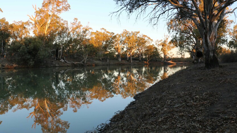
There are many campsites dotted along the Murray River like this one at Lindsay Island (pictured) that bring thousands of people into the area during the bushfire season - Natasha Schedvin
Natural environment
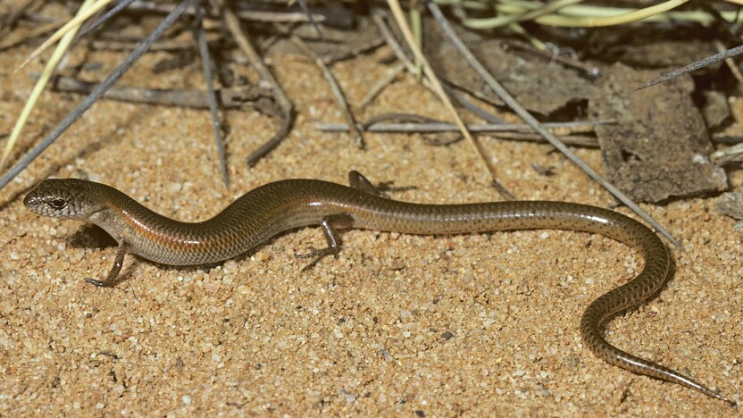
Protecting the natural environment is important to communities of the Mallee. Public land provides important habitat for many species, and ensures it is cared for for generations to come. Habitat also exists on private land.
The Mallee is home to many plants and animals that are found nowhere else in Victoria. Many of them are well adapted to living with bushfire, but not all species can thrive in recently burnt areas.
Major Mitchell Cockatoos need tree hollows that are mostly found in trees that are over 70 years old.
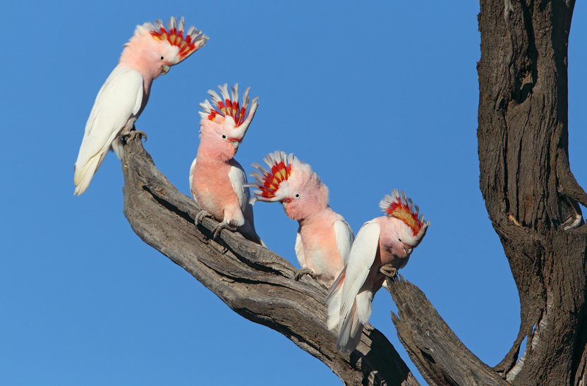
Major Mitchell Cockatoo nest trees (pictured) are vulnerable to bushfires and our strategies are designed to protect areas where these are located - Chris Tzaros
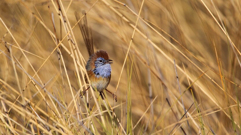
The hummock-grass where the endangered Mallee Emu-Wren live takes over 20 years to become suitable habitat. The same applies for the vulnerable Red-lored Whistler whose Victorian habitat is only found in the Mallee woodlands and scrublands.
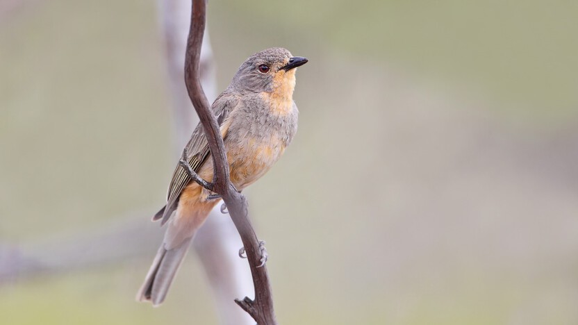
Red-lored Whistler (Pachycephala rufogularis) prime habitat includes areas of Hummock-grass Mallee vegetation - Chris Tzaros
Although habitat for Little Pygmy Possums is found throughout the Victorian Mallee, their numbers vary depending on seasonal conditions. They are also affected by how long since the vegetation they live in experienced fire, which affects the availability of its preffered foods: insects, spiders, scorpions and nectar.
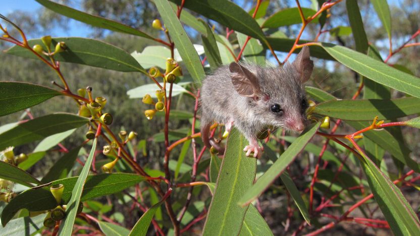
Juvenille Little Pygmy Possum in the Murray Sunset National Park - Natasha Schedvin
We identify priority areas for these animals and other species that are sensitive to fire and consider these carefully in our bushfire management planning. We rank these areas from Highest to Moderate importance based on the number of species dependant on a particular habitat type.
Regional economy
The economy of the Mallee is dominated by agriculture with most of the land area dedicated to cropping and along the Murray River irrigated agriculture. Small areas are used by the extractive industries which exist as sandmining and a range of other small footprint primary production enterprises.
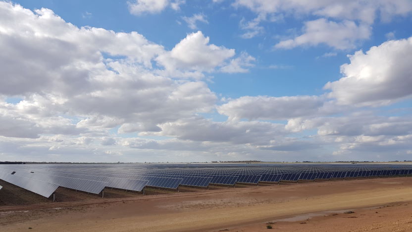
Critical infrastructure
Critical infrastructure in the Mallee includes agricultural areas and associated infrastructure.
This includes pump stations and channels for delivering water, rail and road links that service farms and businesses producing almonds, grapes, dried fruit, citrus and grains.
There is also a rapidly increasing number of solar farms.
 Traditional Owner Groups
Traditional Owners groups, including the Barengi Gadjin and the First Peoples of the Millewa-Mallee, work actively on Country in Central Victoria in partnership with community and agencies.
This work includes protecting cultural heritage and returning cultural burning to Country.
Cultural burning is a practice authorised and led by Traditional Owners.
Traditional Owners conduct cultural burning for a range of objectives, including ceremony, protection of cultural and natural assets, fuel reduction, regeneration and management of food, fibre and medicines, vegetation regeneration, animal habitat protection and healing Country's spirit.
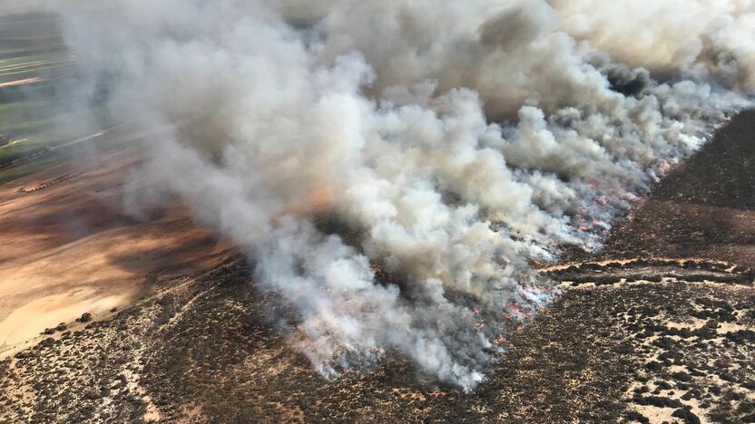
Our bushfire history
This section contains information regarding past bushfires which some readers may find upsetting. Click to skip ahead to bushfire risk in our region or our fuel management strategy.
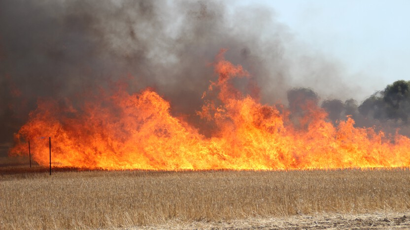
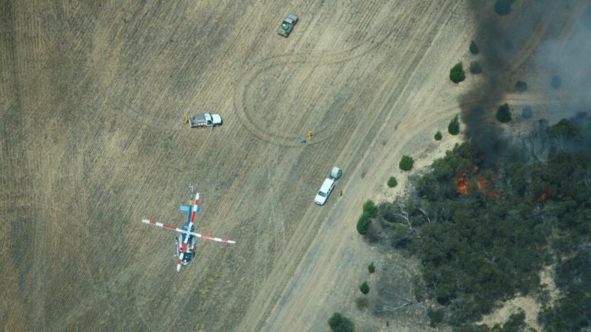
In the Mallee parks, bushfires are usually started by afternoon lightning as part of cold front weather systems that have followed hot days.
Along the Murray River, most fires are started by escaped campfires.
Fires can also start in farmland from human activities such as sparks from harvesting machinery.
The number of fires recorded in the area increases every year, partially due to better detection technologies.
Mallee parks fires
Mallee Parks have regularly been impacted by large bushfires between 10,000 and 200,000 hectares.
Some fires start across the border and then spread into the Victorian Mallee.
In 2002, the Big Desert fire burnt more than 185,000 hectares.
In 2014, multiple bushfires burn burnt almost 106,000 hectares across farmland, state forest and parks including Big Desert Wilderness, Wyperfeld National Park, Murray Sunset National Park and Bronzewing Flora and Fauna Reserve.
During the 2014 bushfires, multiple ignitions in the Mallee and bushfire elsewhere in the state meant firefighting resources were limited. Our prior fuel management activities contributed significantly to reducing the size of these fires.
Bushfire risk in our region
This map shows the risk of house loss in Mallee which is part of the Loddon Mallee region. The map compares where houses could be destroyed by bushfire across the whole region.
Different shades represent different levels of risk. As the shades progress from yellow through red to purple, more and more houses are potentially destroyed.
The purple areas have the highest risk of house loss. More houses could potentially be destroyed by bushfire in these areas than any other areas in this region.
Computer simulations are used to help us estimate houses lost from bushfires. The simulations measure how damaging bushfires could be in different locations. They assume that the fuels in the landscape have increased to the highest level.
This helps us plan where, how often and how much fuel management we do to reduce risks to communities over years, or even decades.
This map does not reflect any recent bushfires or activities that could change the risk in the region. Importantly, this map shows where there is potential for a bushfire to destroy more houses compared to other parts of the region. It does not show risk to individual houses.
The Mallee context
It is considered less likely that bushfires would impact houses in the townships of Kerang, Ouyen, Red Cliffs and Mildura in the same way as similar sized towns in southern Central Victoria part of the Loddon Mallee region.
Grass-fuel loads vary seasonally in the Mallee, particularly with crop growth followed by harvesting. As a result the maximum risk, as shown in the map, is usually the short period between October and December, but can be extended by above average rainfall years.
Above average rainfall also increases fuels in the large Mallee parks which makes bushfires more difficult to suppress and escalates the importance of strategic breaks for controlling the spread of fires.
Our fuel management strategy
By understanding what communities care about, where bushfires have happened before and analysing what areas in the Loddon Mallee region are most at risk, we can create a strategy. This strategy tells agencies where, how much and how often to conduct fuel management activities to reduce bushfire risk.
We classify patches of public land as different Fire Management Zones - Asset Protection Zones,
Bushfire Moderation Zones,
Landscape Management Zones
and Planned Burning Exclusion Zones.
In each of these zones we manage fuels differently in terms of the frequency and intensity of fuel management activities like planned burning.
Where we conduct fuel management each year is determined by a range of factors, including fuel loads and weather conditions, such as rainfall.
'Fuel' is any grass, leaf litter, twigs, bark and other live vegetation which can burn. Fuel builds up at different rates in different areas depending on how fast the vegetation grows compared to how fast it decomposes.
The way we conduct fuel management in the different types of Fire Management Zones on public land helps us to reduce the intensity, severity and spread of bushfires across the landscape. This contributes to reducing the risk of bushfires impacting things we care about.
We monitor the success of our fuel management program and publish the results in our yearly Fuel Management Report.
Township protection
In the fire-prone and fire dependant parts of the Mallee, we use a two-pronged approach to fuel management.
Around towns like Hattah, Murrayville and Walpeup, we have placed small Asset Protection Zones and Bushfire Moderation Zones. Here, we undertake the most intensive treatments to significantly reduce bushfire fuels.
These zones work in combination with Bushfire Moderation Zones within Murray Sunset National Park, Hattah-Kulkyne National Park and Big Desert-Wyperfeld Park complex.
Here, large-scale fuel management is used to create strategic breaks, both on the edge of public land and internally as north-south strips. These breaks are highly effective for the slow growing fuels of the Mallee.
This approach aims to keep bushfires smaller and contained within public land areas in order to protect isolated communities, agricultural production within the surrounding cropping country and the environment.
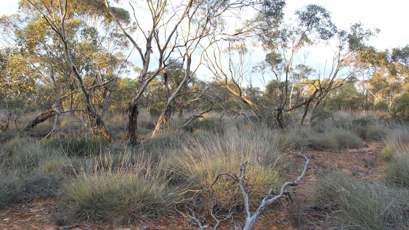
Large Mallee parks and forests
These strips of Bushfire Moderation Zone are carefully positioned to protect the diversity of plants and animals that rely on vegetation of different post-fire ages.
These strategic fire breaks help to break up the landscape and ensure there is always suitable habitat available for native plants and animals
Small fires in the Landscape Management Zones between these breaks can be beneficial to regenerating plant species and the habitat it provides for animals.
For example, in Murray Sunset National Park, species like the Mallee Emu-wren, are only found where there is good hummock-grass cover.
In parts of the park, this grass eventually disappears without fire to stimulate plant regeneration. In other areas, the grass does not need fire to regenerate.
We carefully position our fuel breaks to make sure we don’t lose all of this precious Mallee Emu-wren habitat in one bushfire event.
Bushfire Risk Engagement Areas (BREAs)
To protect the things we care about, agencies and communities need to consider ways of reducing bushfire risk across both public and private land.
On public land, our fuel management activities are undertaken across different Fire Management Zones.
To support bushfire risk reduction on private land, we've identified Bushfire Risk Engagement Areas.
In the Mallee, Bushfire Risk Engagement Areas are defined on public land, around the edges of private property. These areas help agencies to prioritise engagement with the community about managing fuels where it can be most effective. This includes considering a range of actions to reduce bushfire risk.
Where and how we engage with the community will also be informed by current conditions, such as fuel loads and rainfall.
Managing fuels on private and public land begins with a conversation about the benefits and limitations of fuel reduction to meet the needs of our local community and environment.
There is no new legal obligation for landowners within Bushfire Risk Engagement Areas to reduce bushfire fuels on their property.
By working together, land and fire agencies and communities will be able to better protect the things we value from being impacted by bushfire.
For more information or to get involved in fuel management activities on private land, contact your local CFA District.
This concludes our Loddon Mallee Region - Mallee strategy. You can find out more information by downloading the full Bushfire Management Strategy.
Return to the state view to learn about the strategy for the rest of the Loddon Mallee Region (Central Victoria), or to see another region's strategy.